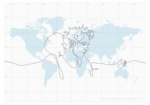
W“ith the help of a GPS device and DHL, I have drawn a self portrait on our planet,” writes Swedish artist Erik Nordenankar on his website for the project, appropriately named the biggest drawing in the world. “My pen was a briefcase containing the GPS device, being sent around the world. The paths the briefcase took around the globe became the strokes of the drawing.” The resulting drawing’s dimensions are 40,076,592 by 40,009,153 meters – which are about the dimensions of the Earth’s surface, if it could be rolled out as a canvas.
Mr Nordenankar sent off his GPS-laden briefcase on March 17, 2008. He gave detailed travel instructions to DHL, which returned his package to Stockholm exactly 55 days later. Then, Mr Nordenankar plotted the spatial and temporal GPS information on a world map to obtain his portrait. “Due to the GPS drawing technique and the magnitude of the drawing, the self portrait had to be made in only one stroke. That giant stroke passed through 6 continents and 62 countries, thus becoming 110,664 km long.”
Assuming that Mr Nordenankar’s briefcase, left Stockholm to the south, its itinerary took it Denmark, up north again to Norway and then in a straight line towards the Crimea, where some expert to-ing and fro-ing formed the artist’s eye. Lines from the Ukraine to central Europa (possibly Slovakia), bending up towards St Petersburg and then south towards the Caucasus form his brow and forehead.
The nose is formed in the Middle East, the right nostril constituted in Syria, a ‘beard line’ snaking across the Mediterranean towards France, the Low Countries and environs, where Mr Nordenankar’s right ear takes shape. His jawline drops south through the Sahara, bending up towards Egypt (mouth) and the Israel/Palestine-Jordan border (philtrum). The briefcase then travelled south along the African Red Sea Coast, over Somalia, performing some strange maneuvers east of Madagascar.
The briefcase then headed north again, hovering just below the Equator, creating an atrophied hand over the Philippines, Indonesia, Australia and Papua New Guinea. The briefcase then continued along the Equator, coming into view on the left hand side of the map (forming Mr Nordenankar’s right arm), crossing America in Panama,diving south past Brazil’s easternmost point to beyond 40° South, and up again (to form some kind of strap or a suspender).
Fancifully swinging across North America, the briefcase rejoined Mr Nordenankar’s face – or rather his curly hair – over the British Isles, tracing his neck across the Iberian peninsula, North Africa’s Atlantic Coast, the African interior and then up again in a curly arc to the Nordkapp (not Europe’s northernmost point; nearby Knivskjellodden is 1,500 meters further north), finally returning to Stockholm.
via
Thanks to tagez for the hint
No comments:
Post a Comment